Views, maps, images, plans...
I'll try to maintain links to various projects we're working on that relate to our property. Some of the links will connect to large images but if they do, I'll tell you what to expect.
Tip: The images open in a new browser window. With a slow connection, instead of waiting for a larger image to load, click on a link with the right button of your mouse and choose "Open in New Window" to load it in a new window. That way, you can switch back to the current window to continue browsing while the image loads. (This works for IE5+; older versions and Netscape users should find something similar if the feature is available. Firefox users can open the image in a new tab.)
3-D rendering
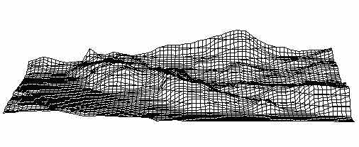
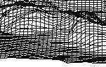 This wire-frame rendering shows the back part of the property and into
Gatineau Park. I created it by plotting elevation data from a topo map
into Excel, then using an algorithm to interpolate data points between
the entered ones. The animation was made by combining a series of chart
images.
This wire-frame rendering shows the back part of the property and into
Gatineau Park. I created it by plotting elevation data from a topo map
into Excel, then using an algorithm to interpolate data points between
the entered ones. The animation was made by combining a series of chart
images.
The animated GIF shows a "flyaround" over the property (339K).
Aerial images
Most of these are from Energy Mines and Resources Canada Aerial Photo Library, where anyone can get aerial shots of most of Canada. Because we border Gatineau Park, many photo runs have been commissioned over the years.
By "morphing" a scanned portion of an image, I can correct for distortions introduced by the location of the aircraft over the property. Then, by stacking the images in layers, I can flip through them and see how things changed over the years. So far, I only have a few years -- albeit going back to 1930 -- and the file is way too big to put up on the web, but I hope to have an animated sample at some point. Stay tuned...
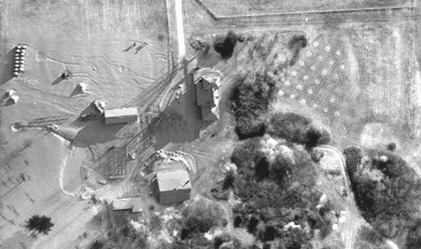
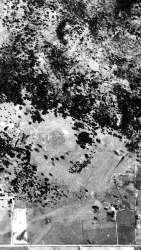 One
of the earliest images is from 1930
and shows the Moss molybdenum mine in operation. If you compare it to
the later images, you can see how much the forest has covered the open
field in the centre of the image. During the mine operations, sample carts
of ore was piled in a grid in this open area so the assayer could examine
them on his regular visits. If the sample pile showed promise, they could
look back in the records and determine where it came from so they could
check the mine face. If a seam of molybdenum looked promising, they could
then bore an experimental horizontal shaft and follow it if the seam proved
worthwhile.
One
of the earliest images is from 1930
and shows the Moss molybdenum mine in operation. If you compare it to
the later images, you can see how much the forest has covered the open
field in the centre of the image. During the mine operations, sample carts
of ore was piled in a grid in this open area so the assayer could examine
them on his regular visits. If the sample pile showed promise, they could
look back in the records and determine where it came from so they could
check the mine face. If a seam of molybdenum looked promising, they could
then bore an experimental horizontal shaft and follow it if the seam proved
worthwhile.
 We
bought this property in 1989 in January, so had no opportunity to see
what lay under the snow. We purchased this
1985 colour image to get an idea of what to expect. The image was
probably taken in early July because some hay has been cut. The lighter
coloured upper part of the field to the east (right) of the house shows
the sand plume resulting from water flowing over the rock outcrop the
the NW of the house. As we discovered later, the house is on 6m of sand,
yet closer to the road and to the north and east of the yard area, it
is clay or clay loam.
We
bought this property in 1989 in January, so had no opportunity to see
what lay under the snow. We purchased this
1985 colour image to get an idea of what to expect. The image was
probably taken in early July because some hay has been cut. The lighter
coloured upper part of the field to the east (right) of the house shows
the sand plume resulting from water flowing over the rock outcrop the
the NW of the house. As we discovered later, the house is on 6m of sand,
yet closer to the road and to the north and east of the yard area, it
is clay or clay loam.
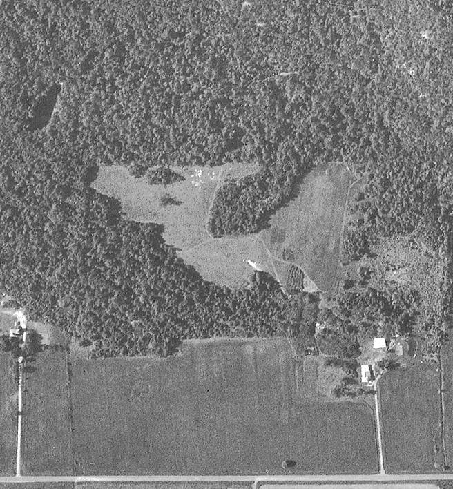
The old Moss Molybdenum mine shows quite clearly in the middle left in this image: we thought it was a beaver pond until we went out to it in May 1989: in fact, it is a 60m deep pit with 5m cliffs around it!
 Compare
this coloured image to the next one to see the effect of the 1986 logging,
and in particular, to the distinctive "tongue" in the back field
where we later found an old pit well.
Compare
this coloured image to the next one to see the effect of the 1986 logging,
and in particular, to the distinctive "tongue" in the back field
where we later found an old pit well.
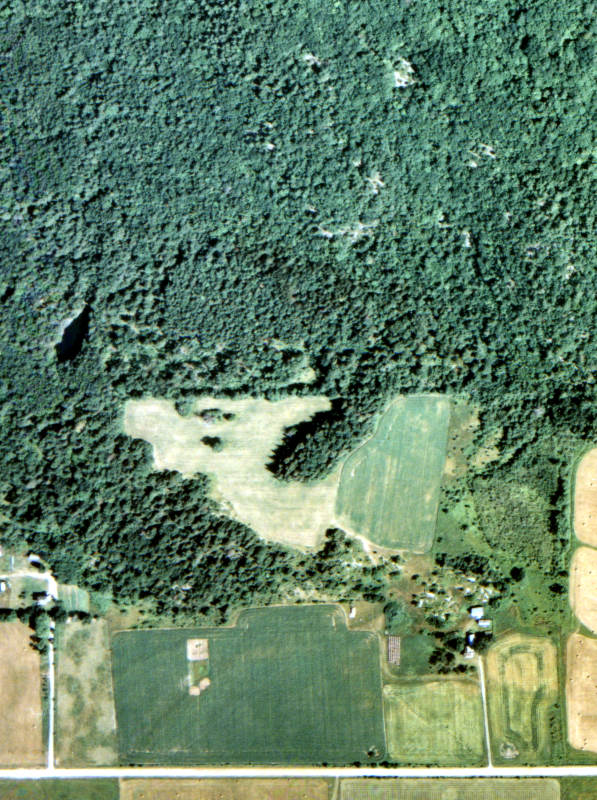
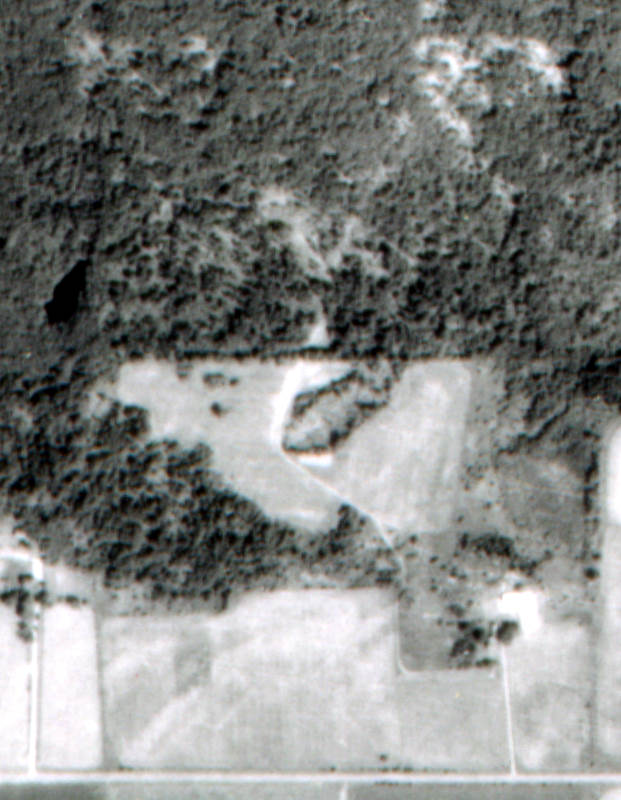
The 1987 image shows the logging done by the previous owners. The trees cut from the "tongue" were very old and large, and their loss caused the area to dry up quite significantly. By 2004, the wet was returning, but the mix of trees was affected by the period of drought. When the pine trees were removed from the back part of the property, the boundary of Gatineau Park is much more apparent. The loggers weren't extremely careful however: the trunks of several prime pines are quite clearly outside of the property line.
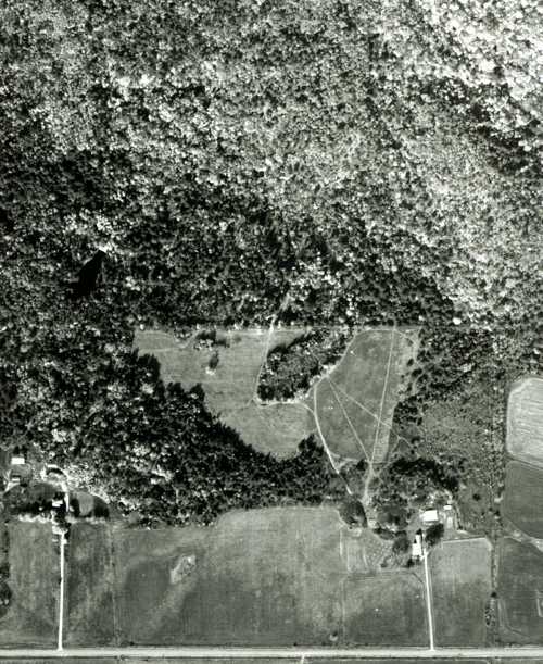 By
1994, when this next image was taken around
Thanksgiving, we'd started making trails and had planted the orchard just
west of the house. The old beach lines in the west field are quite evident
in this image.
By
1994, when this next image was taken around
Thanksgiving, we'd started making trails and had planted the orchard just
west of the house. The old beach lines in the west field are quite evident
in this image.
 Later in that fall, we had a local contractor consolidate the growing
wet area in the west field to contain the water. This area had been getting
larger and larger as the farmer we'd contracted to manage the fields had
to avoid the soft mud in the wet areas.
Later in that fall, we had a local contractor consolidate the growing
wet area in the west field to contain the water. This area had been getting
larger and larger as the farmer we'd contracted to manage the fields had
to avoid the soft mud in the wet areas.
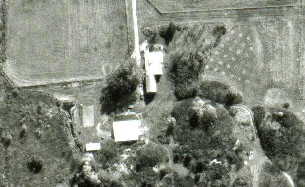
At the same time, we had the pond dug to the east of the garden. In this 1995 photo, taken from a small plane we chartered from Carp Airport, the newly-dug pond shows quite clearly.
In the winter of 2002, a friend used his RC plane to take some very clear images of our yard area. Since they showed the new horse barn, as well as the outline of the pond, I decided to integrate them into the older images. Here are the before and after versions of a detail from the modified 1994 image:
 Before the pond; fall 1994 |
 After the pond; winter 2002 |
 Then,
in 2003 as we left Quebec City, I stopped in to the government mapping
centre to see what kinds of images they had. It turned out to be a real
treasure trove: not only did they have very detailed maps, but they had
aerial images for most of the province -- and would sell them as both
CD and print versions. We now have a very high detail mounted view of
the property on our wall, and a 64MB TIF version of the surrounding area.
This is just a small detail of part of
the big image.
Then,
in 2003 as we left Quebec City, I stopped in to the government mapping
centre to see what kinds of images they had. It turned out to be a real
treasure trove: not only did they have very detailed maps, but they had
aerial images for most of the province -- and would sell them as both
CD and print versions. We now have a very high detail mounted view of
the property on our wall, and a 64MB TIF version of the surrounding area.
This is just a small detail of part of
the big image.
With my GPS, I'll get accurate reference points for locations on this large image and will be able to lay tracks onto it with data saved to the GPS unit while we are horseback riding or hiking. Stay tuned!
![]() Top
This page was last updated on
2005-06-14
Top
This page was last updated on
2005-06-14